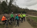
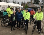
Leader: Rob, Terry
Riders: DerekM, Jo, Anne, Jean, Bill, Mal, Simon; Rhona, Mike, Rowland, John, Steve, DerekS
Distance: 36.2,47 miles
Description:
Stops:
- Coffee: Mohak Cafe (Haslingfield) , Cafe Waresley Park (in the Garden Centre) (Waresley)
- Lunch:
- Warning: thehoops
- Wind speed 12 mph, gusting 21 mph, from the SW (varying between SW and W)
- Temperature average 9°C (8min/10max)
- Feels like 5°C (4min/6max)
- Sun 3.4 hours, cloud cover 89%
- Rain 0.20 mm
Blue
(Download route as gpx file)- Total Distance: 36.24 miles
- Climbing: 1422.9 ft
- Descending: -1380.2 ft
- Max elevation: 261.1
- Min elevation: 45.3
- Elapsed: 05:20:58
- Moving: 02:47:47
Red
(Download route as gpx file)- Total Distance: 47.19 miles
- Climbing: 1507.5 ft
- Descending: -1508.8 ft
- Max elevation: 268.3
- Min elevation: 16.4
- Elapsed: 05:47:20
- Moving: 03:35:18